![](/images/other/stat-length.png)
![Trail Walking La Hague - Tour de la mare de Vauville - Photo](https://media.geolcdn.com/t/1900/400/ext.pjpeg?maxdim=2&url=https%3A%2F%2Fstatic1.geolcdn.com%2Fsiteimages%2Fupload%2Ffiles%2F1553511878bg_sport_marche.png)
Tour de la mare de Vauville
black2boy
User
![Length](/images/other/stat-length.png)
Length
9.2 km
![Max alt](https://static1.geolcdn.com/siteimages/upload/files/1508320355ic_sort_altitude_max_24dp.png)
Max alt
130 m
![Uphill gradient](https://static1.geolcdn.com/siteimages/upload/files/1508320355ic_sort_den_pos_24dp.png)
Uphill gradient
223 m
![Km-Effort](/images/other/stat-length.png)
Km-Effort
12.2 km
![Min alt](https://static1.geolcdn.com/siteimages/upload/files/1508320355ic_sort_altitude_min_24dp.png)
Min alt
3 m
![Downhill gradient](https://static1.geolcdn.com/siteimages/upload/files/1508320355ic_sort_den_neg_24dp.png)
Downhill gradient
222 m
![Boucle](https://static1.geolcdn.com/siteimages/upload/files/16400158638029165_repeat_loop_refresh_sync_direction_icon.png)
Boucle
Yes
Creation date :
2023-09-24 12:56:53.042
Updated on :
2023-09-24 15:08:09.797
![Walking](https://static1.geolcdn.com/sitytour/trail-icons/101.png)
2h10
Difficulty : Medium
![Scan this QR Code to open this trail in the SityTrail application](https://capi.geolives.com/qq0zvz2zws4bq2lad0pu/sitytour/trails/3816837/qr.png?size=200)
FREE GPS app for hiking
About
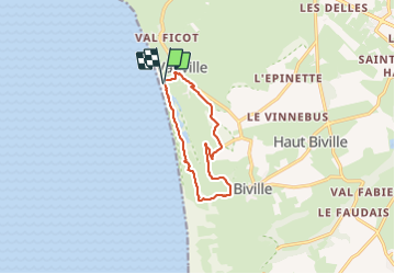
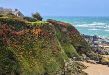
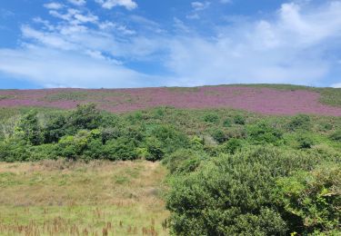
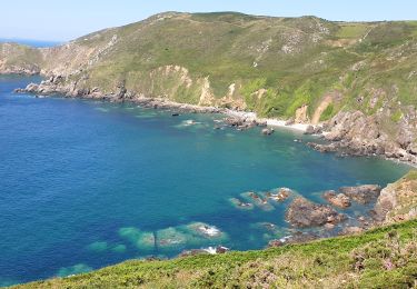
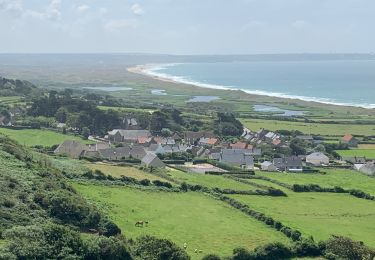
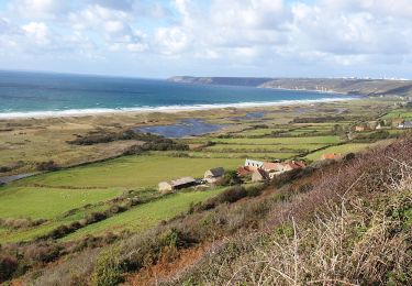
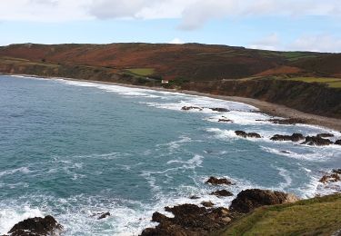
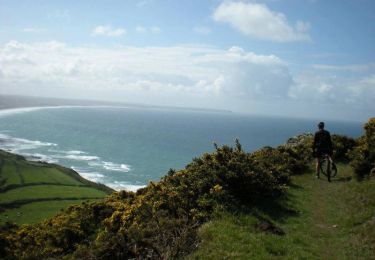
Trail Walking of 9.2 km to be discovered at Normandy, Manche, La Hague. This trail is proposed by black2boy.
Description
Balade agréable qui permet de surplombé la mare et belle vue panoramique sur la plage. un passage difficile lors de la montée vers la croix, 100m de dénivelé parfois raide dans le sable.
Positioning
Country:
France
Region :
Normandy
Department/Province :
Manche
Municipality :
La Hague
Location:
Vauville
Start:(Dec)
Start:(UTM)
583015 ; 5498625 (30U) N.
Comments
Trails nearby
![Trail Cycle La Hague - La Haguarde Bitumeuse 2011 - Gréville Hague - Photo](https://media.geolcdn.com/t/375/260/ext.jpg?maxdim=2&url=https%3A%2F%2Fservices.sitytrail.com%2FGeolivesWS%2FDownloadMedia.ashx%3FTrailID%3D106083%26Media%3D10276_1.jpg)
![Cycle Cycle](https://static1.geolcdn.com/sitytour/trail-icons/200.png)
La Haguarde Bitumeuse 2011 - Gréville Hague
Cycle
Medium
(1)
La Hague,
Normandy,
Manche,
France
![](/images/other/stat-length.png)
61 km | 72 km-effort
2h 0min
![](https://static1.geolcdn.com/siteimages/upload/files/16400158638029165_repeat_loop_refresh_sync_direction_icon.png)
Yes
![Trail Walking La Hague - Séjour Cotentin Etape 4 Biville - Les Pieux - Photo](https://media.geolcdn.com/t/375/260/20c319c1-9c7e-4f29-bee7-385fa39e6485.jpg&format=jpg&maxdim=2)
![Walking Walking](https://static1.geolcdn.com/sitytour/trail-icons/101.png)
Séjour Cotentin Etape 4 Biville - Les Pieux
Walking
Difficult
La Hague,
Normandy,
Manche,
France
![](/images/other/stat-length.png)
29 km | 35 km-effort
6h 55min
![](https://static1.geolcdn.com/siteimages/upload/files/16400158638029165_repeat_loop_refresh_sync_direction_icon.png)
No
![Trail Walking La Hague - ioupi biville 01 - Photo](https://media.geolcdn.com/t/375/260/ext.jpg?maxdim=2&url=https%3A%2F%2Fstatic1.geolcdn.com%2Fsiteimages%2Fupload%2Ffiles%2F1553511878bg_sport_marche.png)
![Walking Walking](https://static1.geolcdn.com/sitytour/trail-icons/101.png)
ioupi biville 01
Walking
Easy
(1)
La Hague,
Normandy,
Manche,
France
![](/images/other/stat-length.png)
9.5 km | 11.3 km-effort
2h 11min
![](https://static1.geolcdn.com/siteimages/upload/files/16400158638029165_repeat_loop_refresh_sync_direction_icon.png)
Yes
![Trail Walking La Hague - Vauville - Photo](https://media.geolcdn.com/t/375/260/2b220e39-b1b1-4526-a0cf-9eab92539eb2.jpg&format=jpg&maxdim=2)
![Walking Walking](https://static1.geolcdn.com/sitytour/trail-icons/101.png)
![Trail Walking La Hague - Vauville - Côte Soufflée A/R - Photo](https://media.geolcdn.com/t/375/260/eb27b005-2ab1-4642-aace-d7963dce8dc5.jpg&format=jpg&maxdim=2)
![Walking Walking](https://static1.geolcdn.com/sitytour/trail-icons/101.png)
Vauville - Côte Soufflée A/R
Walking
Very difficult
La Hague,
Normandy,
Manche,
France
![](/images/other/stat-length.png)
22 km | 33 km-effort
4h 32min
![](https://static1.geolcdn.com/siteimages/upload/files/16400158638029165_repeat_loop_refresh_sync_direction_icon.png)
Yes
![Trail Walking La Hague - Gag - Photo](https://media.geolcdn.com/t/375/260/b3b09df4-3380-48d8-b0c7-2a859452b91a.jpg&format=jpg&maxdim=2)
![Walking Walking](https://static1.geolcdn.com/sitytour/trail-icons/101.png)
![Trail Walking La Hague - Vauville, dunes de Biville Héauville - Photo](https://media.geolcdn.com/t/375/260/26dd8ef3-68e9-4a0b-a9e4-59cc22a7a231.jpg&format=jpg&maxdim=2)
![Walking Walking](https://static1.geolcdn.com/sitytour/trail-icons/101.png)
Vauville, dunes de Biville Héauville
Walking
Easy
La Hague,
Normandy,
Manche,
France
![](/images/other/stat-length.png)
21 km | 25 km-effort
4h 13min
![](https://static1.geolcdn.com/siteimages/upload/files/16400158638029165_repeat_loop_refresh_sync_direction_icon.png)
Yes
![Trail Walking La Hague - Herquemoulin-Cap de la Hague - Photo](https://media.geolcdn.com/t/375/260/5a35c261-cb44-47dd-89d5-6c3138309710.jpg&format=jpg&maxdim=2)
![Walking Walking](https://static1.geolcdn.com/sitytour/trail-icons/101.png)
Herquemoulin-Cap de la Hague
Walking
Difficult
La Hague,
Normandy,
Manche,
France
![](/images/other/stat-length.png)
16.9 km | 26 km-effort
4h 9min
![](https://static1.geolcdn.com/siteimages/upload/files/16400158638029165_repeat_loop_refresh_sync_direction_icon.png)
Yes
![Trail Mountain bike La Hague - La Banane à Vauville - Photo](https://media.geolcdn.com/t/375/260/ext.jpg?maxdim=2&url=https%3A%2F%2Fservices.sitytrail.com%2FGeolivesWS%2FDownloadMedia.ashx%3FTrailID%3D215233%26Media%3D15852_3.jpg)
![Mountain bike Mountain bike](https://static1.geolcdn.com/sitytour/trail-icons/202.png)
La Banane à Vauville
Mountain bike
Difficult
La Hague,
Normandy,
Manche,
France
![](/images/other/stat-length.png)
42 km | 56 km-effort
3h 30min
![](https://static1.geolcdn.com/siteimages/upload/files/16400158638029165_repeat_loop_refresh_sync_direction_icon.png)
Yes